
Wapta Icefield Trip
- Blog Writer
- Aug 15, 2023
- 4 min read
On July 21, six ACC Manitoba members (Ali, Erica, Jodi, Josée, Ray, and Terry) set out on a four-day adventure onto the Wapta Icefield with Mountain Guide Erica Roles.

ACCLIMATIZATION - HA LING
(Time: 3h 46m – Gain: 2,467ft)
Flatlanders arrive in the mountains slightly anemic. There's nothing like a hike up to the top of Ha Ling to help jack those red blood cells into overdrive. Oh, and the views overlooking Canmore are stunning!


TRIP AT A GLANCE

DAY 1 - ASCENT FROM BOW LAKE TO BOW HUT
(Time: 4h 5m – Gain: 1,512ft)
Our four-day adventure started at the beautiful Bow Lake, along the Icefield Parkway. Time for a quick shot at the shoreline before making our way to the back, where the source of the lake's water has cut a deep gorge into the rock. The only way across is over a large rock that was trundled into place for this very purpose. There would be a few more river crossings on the trip, but no large rocks to keep our feet dry.
After a four-hour ascent, we arrived at the Bow Hut, which is a large H-shaped building with cooking/dining in one leg, and sleeping in the other. The two legs are connected by a hallway with two indoor biffies. We had a few groups join us for the night and it did not feel crowded. After a nice meal, it was early to bed, in anticipation of an alpine start (up at 4:00am and out by 5:30am).


DAY 2 - BOW HUT TO PEYTO HUT - CLIMB MOUNT RHONDDA
(Time: 9h 29m – Gain: 2,372ft)
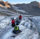
The toe of the glacier is a short walk from the hut, so time to don the crampons and make the journey on the glacier to Mount Rhondda. While there were a few crevasses along the way, no complex labyrinths to negotiate (that would be for the trip to Mount Habel).
The climb to the summit of Rhondda would be a scramble followed by a 1.5km hike on a wide plateau. After a quick bite, we retraced our steps back to the glacier, for a descent to Peyto Hut. Along the way, it was great to have the opportunity to fill the water bottles with the most delicious tasting glacier water!


DAY 2/3 - AT PEYTO HUT
The hike up to Bow Hut is just that, a hike. When you travel to Peyto Hut, you realize you've entered the world of mountaineering - harnesses, glacier travel, crevasses, route-finding.
It was nice to have two nights in Peyto Hut so we could settle in a bit more. A much smaller hut than Bow, it still did not feel cramped, even as another group joined us for our second night. One of the nicest features of the hut is the lake that is a five-minute stroll in sandals. Not being a glacier-fed lake, it was warm enough for a quick dip to freshen up for the evening.
When we say evening, we really mean afternoon, because we were in our sleeping bags by 8:00pm to get a good sleep before another alpine start.


DAY 3 - CLIMB MOUNT HABEL
(Time: 8h 26m – Gain: 2,253ft)
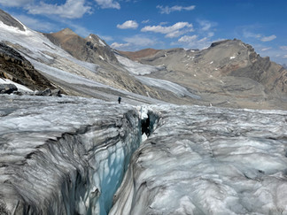
With headlamps on, we began our journey across the glacier. A crevasse field was visible in the distance, so there would be some navigating to do. But, our guide, Erica Roles, made short work of it, as she found an easy way through that required some belaying at only one crossing.
Most of the trip to the summit was on a dry glacier (not snow-covered), so it was a nice walk without the need for a rope. As we got closer, we needed to stay away from a bergschrund on Mount Rhondda and rock face on Mount Habel. So, we moved onto the snow-covered glacier, and navigated across with only one person's leg punching into a crevasse.
The most exhilarating part of the day was a steep angle ice ascent to the summit ridge - a perfect opportunity to practice short-roping and walking like a cowboy - (you don't want to trip on your crampons)! The summit ridge was easy to negotiate with some mild exposure along the way.
The descent afforded another opportunity to fill the water bottles with delicious glacier water before making it back to the hut for a relaxing afternoon.


DAY 4 - DESCENT TO PEYTO LAKE
(Time: 6h 31m – Loss: 1,916ft)
One last alpine start, but this time, up at 4:00am and out the door just after 5:00am (we were getting things dialed in). We were off the glacier in no time and travelling down a large lateral moraine, a standoff with a group of mountain goats, across the rushing river, and to the parking lot just before noon.
On the descent, we could see how much the glacier has retreated over the last few years (in the first picture, the glacier used to extend to the far end of the lake).
Our final picture was at the platform overlooking Peyto Lake. In the distance, you can see Mount Habel surrounded and covered by ice, where we stood atop just a day previous. You couldn't help but feel a sense of accomplishment, especially standing amongst the tourists who may wonder what it's like up there - we know!


Comments